


SEJournal Online is the digital news magazine of the Society of Environmental Journalists. Learn more about SEJournal Online, including submission, subscription and advertising information.
June 5, 2019

Reporter’s Toolbox: FED Tool Tracks Pollution on Federal Lands
EDITOR’S NOTE: Starting today, we’re revamping Reporter’s Toolbox! The long-standing column will now focus on the world of data journalism, with an emphasis on the data tools, techniques and database resources that you can use to improve your environmental reporting. Also, Toolbox is increasing in frequency, publishing twice a month beginning with this column. Our newly named Toolbox Editor Joseph A. Davis will alternate Toolbox with his now twice monthly TipSheet columns. Let us know what you think via comments or via email to sejournaleditor@sej.org. Thanks and enjoy!
By Joseph A. Davis
The nation’s parks may be pretty, but unfortunately not every one is pristine.
For environmental journalists trying to figure out which is which, there’s a nifty searchable online database that can tell them about pollution conditions in parks, forests and other federal lands.
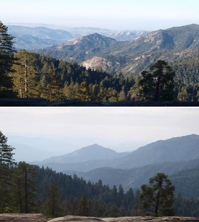 |
| Visibility comparisons from Sequoia and Kings Canyon National Parks, which have some of the worst air pollution of any national parks in the United States. The lower of the two images shows mountain ranges obscured by haze. Photo: National Park Service. Click to enlarge. |
It’s called Federal Land Manager Environmental Database ... yes, FED.
For starters, the FED tool gives relevant air quality data for a wide range of federal lands, not just parks and forests, but fish hatcheries, and sites for the military and NASA. It relies on other federal databases, but presents them through a fast and powerful portal.
Why should you or your community care?
Well, it’s nice to find blue skies when you go camping, so that you can enjoy, er, blue skies. Not only are brownish or yellowish skies in a national park a bummer, but you may find yourself wheezing a bit while hiking up the mountain.
That’s because soot and smog aren’t just for cities. They often spread over wide distances.
The 1977 revision of the Clean Air Act addressed this issue — mandating that the U.S. Environmental Protection Agency control pollution that impairs visibility in national parks and wilderness areas.
EPA issued its first “Regional Haze Rule” in 1980, then issued a major update in 1999. The rule requires states to have pollution-control plans to address visibility problems when they exist in some 156 park and wilderness areas.
EPA’s Regional Haze Program has not always been the agency’s top priority, but it has improved visibility in many areas (nice maps here).
Still, there is low-level ongoing conflict between some states and EPA (along with land-management agencies) over periodic revision and approval of state plans.
That’s why the FED tool is handy for environmental journalists. While it is sponsored by the National Park Service and U.S. Forest Service, it is actually managed by Colorado State University’s Cooperative Institute for Research in the Atmosphere, or CIRO, which routinely handles all kinds of high-tech Earth observation data, such as that from satellites.
The FED data tool integrates
several dozen pollution data sets
in a fairly useable and elegant portal.
The FED data tool integrates several dozen pollution data sets in a fairly useable and elegant portal. The query engine is easy to use, fast, visually adept and generally non-clunky. It even links to live webcams and visibility photos.
While most of the data in FED relates to air quality, some relates to water quality issues such as acid rain.
The bad news is that not all data is perfect. But the good news is that when the FED misses a step, it gives you extensive and meaningful error messages.
Data behind the database
If you are seriously exploring this arena, you may want to be aware of some other data sources used by FED.
EPA’s Clean Air Status and Trends Network, or CASTNET, is one of them, in fact, a major source of FED data. It includes a network of monitoring sites and records things like dry deposition.
You should also be aware of AirNow, which presents air-quality data from monitoring stations in near real time and in a graphical map format. While EPA is at the center of this project, it is a collaboration with other agencies such as the National Oceanic and Atmospheric Administration, or NOAA, the National Park Service, and state, tribal and local air agencies.
You can also see EPA’s network of outdoor air quality monitors here. For further federal data, look here.
Anyone reporting on regional haze issues also needs to be aware of the Trump EPA’s deregulatory push in this area (in fact, that may be why you are covering it). EPA’s then-Acting Administrator Andrew Wheeler issued his “Regional Haze Reform Roadmap” back in Sept. 2018.
You can see a release here and a memo here, as well as a critique from the National Parks Conservation Association here.
Joseph A. Davis is a freelance writer/editor in Washington, D.C. who has been writing about the environment since 1976. He writes SEJournal Online's TipSheet and Reporter's Toolbox columns. Davis also directs SEJ's WatchDog Project and writes WatchDog Tipsheet and also compiles SEJ's daily news headlines, EJToday.
* From the weekly news magazine SEJournal Online, Vol. 4, No. 23. Content from each new issue of SEJournal Online is available to the public via the SEJournal Online main page. Subscribe to the e-newsletter here. And see past issues of the SEJournal archived here.
SEJ Publication Types:
Topics on the Beat:
Region:
Visibility:

