


SEJournal Online is the digital news magazine of the Society of Environmental Journalists. Learn more about SEJournal Online, including submission, subscription and advertising information.
September 19, 2017
TipSheet: As Hurricanes Strike, Surge Coverage Can Save Lives
While mass casualties were avoided with recent Hurricanes Harvey and Irma, when hurricanes do kill, they generally kill not with wind but with water.

And storm surges (subscription required) are one of the most lethal aspects of a hurricane. Since they evolve dynamically in real time, reporters looking for local environmental stories in surge-prone areas would be wise to prepare their tools ahead of time.
A storm surge is a temporary rise in sea level accompanying a hurricane or tropical storm. That means flooding of land that is usually dry. Surges can be anywhere from less than a foot to (in extreme cases) 15 or 20 feet. That’s enough to kill people and damage property.
Several mechanisms cause surges. The most important is wind. The high winds of a storm push the surface waters in one direction, piling them up when they reach shore.
Another factor is the low atmospheric pressure at the center of a storm. The higher atmospheric pressure all around it on the sea pushes up a dome of water in the center, which is the surge when that dome moves onshore.
When a storm surge coincides with a high tide, the effect is worse. Higher waves generated by storm winds will further exacerbate the problem. The direction and speed of a storm’s progress count, too. And sea-level rise caused by global warming is also a factor — one that will increase in coming years.
Terrain matters as well. Some terrain, like barrier islands and wetlands, can actually diminish surge effects. But when the sea-floor rises gradually (a shallow slope), the surge may be higher. And when coastal landforms blocking a surge “funnel” it to a central point, the surge is amplified.
When the land onshore is low-lying, the surge will also be more harmful. Hurricanes drop large amounts of rainwater on land, and drainage may be impeded when that water has nowhere to go because of a surge — adding to the flooding problems in cases like Harvey. When hurricanes and surges hit large and complex estuaries, things get even dicier.
Predicting the chaos a big challenge
The point is that every surge situation is unique.
Take Katrina. The underlying problem is that much of New Orleans is below sea level, kept dry by levees. The Katrina surge caused levee failure, and water sought its own level, which is what inundated the city. In Irma, the storm was so wide that forecasters had to calculate surge scenarios for both the East and West coasts of Florida.
You can prepare for surge-related flooding by learning about your local or regional situation.
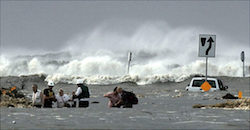 |
| Hurricane Ike storm surge, September 2008. Photo: NOAA |
One essential helper: the National Storm Surge Hazard Maps put out by the National Oceanic and Atmospheric Administration. Find the NOAA maps online here. Heed the caveats that come with them. They are a generalized and hypothetical scenario of what could happen in a near worst-case storm, based on computer modeling applied to known topography. But they will help you guess who needs to worry most.
But that’s only the beginning. As Irma demonstrated, it is hard to predict in the chaos of a hurricane which areas the surge will harm the most.
For instance, the heading and path of the storm are key factors. The right-front quadrant of a hurricane is considered the most dangerous for surge, so it matters where it hits. But because cyclone winds rotate, and winds are the major cause of surge, the back side of a hurricane can cause surge in the opposite direction from the front.
This is why we need meteorologists. And why initial predictions (subscription required) are not always right. The veering and wobbling of Irma’s path over Florida partly fooled many forecasters. Few expected Jacksonville to get the high waters it got. Many observers expected a big disaster in the Tampa Bay area.
You, as a local or regional reporter, can add to the map things that meteorologists don’t always see — the people in the way of the water, the residential and commercial development on a particular area of land.
Follow storm advisories obsessively
Another helpful tool will be your state and local evacuation zone maps. These are prepared by state and local emergency management agencies. Here are examples for Florida and for Broward County.
But you will have to find the ones that apply to your own area — ahead of time. Try Googling “evacuation zone, maps” with the name of your state or county.
Keep in mind that NOAA’s National Hurricane Center issues advisories during storms that include information on storm surge threats. If you are covering hurricanes you should follow these obsessively. Every storm has its own series of advisories, and you can find the latest on a particular storm by starting here.
Wherever you are, there is a NOAA National Weather Service local office not far away. Now is a good time to learn how to connect with them. Click through to the local hazardous weather advisories, and bookmark them.
Alternatively, get a NOAA weather radio, and you will hear the same advisories. This system includes the Emergency Alert System, a locality-specific array of warnings that includes storm surges along with many other threats. Pay attention to marine weather advisories and coastal flood advisories.
* From the weekly news magazine SEJournal Online, Vol. 2, No. 35. Content from each new issue of SEJournal Online is available to the public via the SEJournal Online main page. Subscribe to the e-newsletter here. And see past issues of the SEJournal archived here.
SEJ Publication Types:
Topics on the Beat:
Region:
Visibility:

