


SEJournal Online is the digital news magazine of the Society of Environmental Journalists. Learn more about SEJournal Online, including submission, subscription and advertising information.
January 15, 2014
Special Feature
By BILL ALLEN and SANGEETA SHASTRY
 |
|
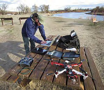
University of Missouri Senior Brendan Gibbons downloads a digital video file after a journalism drone flight in April. He was at the confluence of the Gallatin, Jefferson and Madison Rivers, where they form the Missouri River, near Three Forks, Mont. The video became part of an online story explaining the workings of the Missouri headwaters. On the table are the aircraft, a radio controller, iPad for weather reports and directions, small digital audio recorder, and Mac laptop. Photo by Bill Allen / University of Missouri.
|
As a light April sleet driven by a 25-mph wind pinpricked his face, Brendan Gibbons guided a quadcopter drone into the sky near an oil rig along the Missouri River in western North Dakota. He was standing on a dirt road in the Little Missouri National Grassland, one of several areas where industry is using hydraulic fracturing techniques to pump oil from the Bakken Shale.
Gibbons, then a senior in the Science and Agricultural Journalism Program at the University of Missouri, had seen satellite photos showing what he described as “like a new city” that had sprouted in North Dakota’s oil patch. He wanted to get a closer view from above, so we drove the 1,100 miles from Columbia as part of a drone journalism class.
What happened next was an exercise in the trials and possibilities of environmental journalism using small, relatively low-cost drones equipped with tiny video cameras and other imaging devices.
A gust nearly swept the drone away when it climbed to 50 feet, but Gibbons pushed forward on one of the two joysticks on the radio-control box in his hands, leaning the aircraft into the wind and back toward the rig. He pushed the other joystick to move the drone higher: 100 feet, 200, perhaps 300. The attached GoPro HD video camera continued to run.
A few minutes later, with the drone batteries drained and the quadcopter grounded, he walked back to the frigid car, loaded the video file onto a laptop and viewed the result. He had gotten an airborne image of the well, with its bright flare of burning “waste” methane and the river in the background.
But the fish-eye lens of the camera, hampered by the haze of storm cloud and dusk, wasn’t up to the task of recording the other piece of the scene he had wanted to capture — the flares from dozens of other wells on the opposite shore.
Still, the wobbly image of the well and the river became part of a story package Gibbons produced for the website of KBIA, the National Public Radio station run by the Missouri School of Journalism.
The package, including a 1,100-word story and three-minute video, documented potential environmental threats and the political pressure put on the Army Corps of Engineers to let the industry use Missouri River water for free to feed the Bakken oil boom. The video, although rudimentary by professional broadcast journalism standards, shows how close the leaky oil operations are to the river.
He didn’t get the shot he’d hoped for, but “the drone was never meant to replace a reporter’s most effective tools — interviews and documents,” said Gibbons, who now covers the environment for the Scranton (Pa.) Times-Tribune. Later in the trip, he flew the drone in the Montana Rockies for a story on the Missouri River watershed.
 |
|
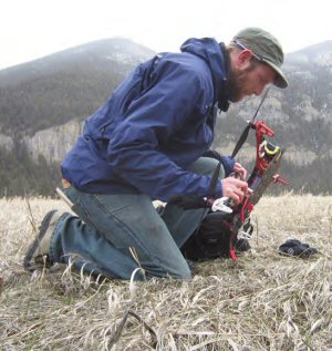
In a light April snow in the mountains south of Bozeman, Mont., Brendan Gibbons prepares the journalism drone for a flight high in the Missouri River watershed, along the Gallatin River. His story traced the fate of snowflakes and other precipitation, some of which goes into the Gallatin, then the Missouri, then the Mississippi River north of St. Louis and ultimately the Gulf of Mexico. A GoPro video camera is mounted near the front propeller. Photo by Bill Allen / University of Missouri.
|
Rising interest, little expense
Today, what Gibbons did would be illegal. But let’s get to that in a minute. First, some basics: These are not your military’s drones.
A typical quadcopter drone like the ones most SEJ members might use is a radio-controlled “model” aircraft weighing roughly three to four pounds, about the diameter of a garbage-can lid and generally no more than a foot high, including landing skids. The other general type is a single-engine fixed-wing aircraft not much bigger, except for length and wingspan. An excellent drone and video camera combo costs about $1,000, although cheaper models would work, too.
“They’re a cheap replacement for a news helicopter, and they go places that are unsafe to fly or difficult to get to,” said Matthew Schroyer of the University of Illinois, who founded the Professional Society of Drone Journalists in 2011. Schroyer was a panelist in the drone journalism session at the October SEJ meeting.
“Drones are all about providing perspectives, whether aerial images to support a story or to obtain data that would otherwise be available only to governments,” he said.
The term “drone” is the subject of much debate, since it is emotionally charged and often taken to mean a war-fighting aircraft by the public and photo editors. Hobbyists call it a UAV, or unmanned aerial vehicle, and government and industry call it a UAS, or unmanned aircraft system. A UAS is a small one, weighing under 55 pounds, according to the Federal Aviation Administration. Trust me, the list continues, but those are the ones most in vogue.
The expectation of most of us who’ve dabbled in drone journalism is that the term drone, now so widespread in public use, will follow “Kleenex,” “Star Wars” and perhaps “pink slime.” That is, it’s here to stay.
For a good discussion of the attempts by various stakeholders to substitute other names and acronyms for the emotionally charged term “drone,” see Australian journalist Mark Corcoran’s “Drone Wars: The Definition Dogfight.”
Already, whatever their moniker, they’re being studied or used for a wide range of practical civilian applications, including precision agriculture, emergency response, disaster relief, geological surveying, anti-poaching enforcement, and delivering vaccines and medicines to inaccessible areas. In December, Amazon announced plans to deliver packages to customer doorsteps with octocopters, perhaps within a decade.
Word of advice? Everybody crashes
Leading news outlets in the United States say their newsrooms are ready to begin incorporating drone technology. Journalists at overseas media companies such as the BBC World Service and the Australian Broadcasting Corporation have already incorporated drones into their reporting. The images and other information drones can collect, and their capability for getting to high-risk or low-accessibility areas, make them powerful reporting tools.
Because of their multimedia potential and relatively low cost (helicopters generally run $1,000 an hour), drones can even the playing field and lower barriers to entry for smaller news organizations looking to develop new technologies and sustain their competitiveness. Local news coverage in particular could benefit greatly. They’re also easily obtained. You could finish this article, go to amazon.com and have a fully-equipped, almost-ready-to-fly DJI Phantom quadcopter delivered to your door tomorrow.
Word of advice: Practice for a few days before trying anything fancy. A newbie hobbyist in New York City in October got too fancy when his drone took off from a high-rise terrace, bounced off a few skyscrapers and crashed on the street near Grand Central Station at rush hour, nearly hitting a man. The near-victim gave the drone’s video card to a TV station. New York police found the pilot and charged him with reckless endangerment.
That’s just one example.
Find a grassy, open field. And go easy. Find a teacher. No one learns without crashing. As one of my students said in his post-class evaluation:
“The laws of physics apply to our work with drones in a way they never have for journalists before. And velocity has a lusty appetite for money. If I were to write a flight-training manual for drone journalists, I’d call it ‘Everybody Crashes’ and cross my fingers and hope the guy who wrote ‘Everybody Poops’ doesn’t sue me.” (Name withheld to avoid lawsuit.)
Red tape slowing innovation in drone journalism
One more word of advice to would-be drone journalists: don’t do journalism yet.
Until 2007, the only guidelines the FAA had for model aircraft users were voluntary. A 1981 advisory circular encouraged hobbyists to fly below 400 feet in altitude, in rural areas, in daylight and within sight of the (ground-based) pilot. That circular left out any form of profit-making using a drone, including traditional news outlets. It also left out “public” entities, somewhat ambiguously defined later as government agencies, law enforcement organizations and universities.
A 2007 FAA policy statement, however, mandated that anyone other than a hobbyist had to get FAA permission via a maze of paperwork that, at best, took months. This Certificate of Authorization, or COA, for public unmanned aerial systems involves detailed questions about device safety, safety precaution plans while flying, pilot qualifications, procedures for reporting accidents, devices such as sensors or cameras attached to the drone, and flight plans and maps, among others.
What appears to be the first legal action involving civilian drone use resulted from a $10,000 fine levied by the agency against Team Blacksheep, a group of drone hobbyists who shot footage of the University of Virginia’s medical campus in October 2011. The group was approached by advertising representatives who wanted to use the footage.
After the FAA saw the video, the agency cited Team Blacksheep, which did not have a COA. The group’s attorney, Brendan Schulman, filed a motion to dismiss, arguing that the FAA does not have jurisdiction over the low altitudes at which civilian drones fly. But the agency recently responded to the contrary, arguing that it has control over all airspace, primarily to protect other aircraft and people on the ground.
Schulman also noted that the regulations governing the fine did not allow for proper public notice and comment. That, he argued, meant stakeholders were not given a chance to propose amendments to the regulations. Because some other countries do not have the same kinds of restrictions and red tape that the United States does, drone innovation — in journalism and other fields — was being slowed, he said.
Universities poised to lead the field
Meanwhile, over the past couple of years, some journalism professors began to prepare students in drone journalism, feeling that the FAA ban for universities only included researchers. No one would make any money if student journalists did drone journalism and posted it on non-profit websites. Rather, their students fell into the hobbyist category.
The University of Nebraska in 2012 and University of Missouri in 2013 began to produce stories containing drone footage. It's no coincidence that they focused mainly on environmental reporting since they had to fly in unpopulated areas to abide by FAA restrictions.
At Nebraska, students led by Matt Waite, professor of journalism, produced a pioneering story on the Platte River in drought that included stunning images of the all-but-parched river and a few braids of shallow water (links to the story and to a video on how the Nebraska team produced it). The story was posted on a university website and was picked up by news media around the world.
At Missouri, in collaboration with public radio web content manager Scott Pham, our class produced six stories: on a prescribed prairie burn, snow geese migration, wheat research, the Cahokia Mounds archaeological site, the headwaters of the Missouri River, and Gibbons' package on North Dakota oil.
In July, the FAA sent registered letters to our programs telling us to stop. In short, officials said, university-based, non-commercial journalists were not hobbyists. Since we were based at a "public" institution, we needed a COA.
Our universities, and a few others that now study drone journalism, await action by the FAA. In 2012 Congress ordered the agency to write new regulations by September 2015 that would open drones to commercial use and other civilian use.
The FAA 'roadmap'
On Nov. 7, 2013, the FAA released what it called a "Roadmap" for integrating civilian drones into the national airspace. The document showed the agency intended to integrate small UAS (the ones under 55 pounds) sooner than larger ones and hinted that some sort of pilot certification would be required, possibly including a training course and exam.
The roadmap indicated that "public" drone use would be approved before commercial use, according to Schulman, the Team Blacksheep lawyer. A proposed plan for such use may be released for public comment in early 2014.
Since public drone use would include state universities, college students may be back at the leading edge of U.S. drone journalism again, if only for a relatively short time.
"The document really just gives hints as to what's to come for legal drone journalism in the U.S.," Waite said on his website. "But that's more than we've had up to now. In short: Heads up in the New Year."
Also in 2014, state legislatures are likely to see a rise in the intensity of the anti-drone campaign. In 2013, legislative action emphasizing privacy rights flourished, creating some strange bedfellows. In Missouri, for example, the Farm Bureau and the American Civil Liberties Union joined in January to support House Bill 46. The bill, which passed the House but died in the Senate, would have curtailed the use of drones to collect information. In September, a Texas law went into effect that outlaws publishing data, images or any other information collected by a drone.
"To date there have been 42 bills introduced into state legislatures that we consider to be anti-UAS legislation," Mario Mairena, government relations manager for the Association for Unmanned Vehicle Systems International, said at the SEJ meeting. "All of them are focused around the area of privacy."
The AUVSI has 7,500 members from government organizations, industry and academia, Mairena said. The group advocates for unmanned systems and robotic technologies in the defense, civil and commercial sectors, including journalism.
Waite and others expect a new wave of legislation in 2014 and have led conversations on how to make journalism's case. At a Drones and Aerial Robotics Conference at New York University Law School in October, speakers called for journalists to develop a unified plan, and to work with the FAA and state and national legislators to implement policies that both protect privacy rights under the Fourth Amendment and allow reporters to use this tool to inform the public under the First Amendment.
Let the brainstorm begin
Any journalist who saw the January 2012 story about pig blood flowing into the Trinity River in Dallas can understand the great potential for drones in environmental reporting.
An unidentified drone hobbyist flew along the river and noticed in his aerial images a red stream flowing near a slaughterhouse and into the Trinity. Government officials shut down the plant and fined its owners.
In November of that year, when public radio's Scott Pham walked into the office of one of the authors (Allen), said he had a drone and asked if Allen wanted to teach a course on drone journalism, Allen had two questions:
- What do you mean, "drone?"
- When do we start?
 |
|
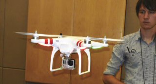
Cade Cleavelin, a senior in science and agricultural journalism at the University of Missouri, demonstrates a DJY Phantom quadcopter at the SEJ Conference in Chattanooga, TN last October. Photo: © Roger Archibald.
|
Somewhere in between those two questions the image of a stream flowing with pig blood popped into Allen's mind.
That shudder of excitement can be yours. While we wait for — or help guide — drone journalism policy to be set, let the fun of story-idea generation begin. To fuel your brainstorming (suggestion: get together with environmental journalism friends at a pub), here are a few recent stories or story ideas showing the possibilities for using the low-altitude angle. They were gleaned from the SEJ panelists, the NYU conference and news reports.
- Waite said he was working with computer science and engineering colleagues at Nebraska to develop a drone-based water-sampling device for investigative reporting on water quality. He suggested SEJ members think about how they might use the device in their areas.
- Schroyer suggested using drones to obtain high-resolution images of landscapes to measure changes in the environment.
- CNN and a British photographer used drones to show video of the widespread destruction caused by Typhoon Haiyan in thePhilippines: CNN and One News Page.
- Conservation groups and others have deployed drones in Africa and Asia to combat poaching of endangered animals.
- Cameron Hickey, a producer with the PBS programs NOVAand NewsHour, said he had captured images and video of the aftermath of Hurricane Sandy in New York City. (Hickey said he received no payment for that footage in particular, although the footage was ultimately broadcast on PBS.)
- Employees of Falcon UAV, a Colorado-based company, used a mapping drone to gauge risk and damage during that state's flooding crisis in September. They provided footage and data to first responders until the Federal Emergency Management Agency grounded the company's drones.
- Corcoran, the Australian journalist, suggested that using drones to report on the aftermath of the 2011 Japanese earthquake, including the disaster at the Fukushima Daiichi nuclear power plant, could have reduced the risk of radiation exposure and injury.
- Schroyer flew a drone over the small town of Gifford, Ill., two days after an EF-3 tornado ripped apart 200 houses there during a tornado outbreak that killed six people in Illinois and two in Michigan.
What would Brendan Gibbons do?
After all, he is arguably among the most experienced drone journalists in the country, and he's working for an excellent newspaper in Scranton, in the middle of Marcellus Shale region. As he waits for the FAA, he's thinking of ways to use a drone.
"For breaking news, I could see a drone's-eye view being useful for a pipeline explosion or major spill event," Gibbons said. "Another possibility would be hovering over public lands to determine the extent of deforestation necessary to build roads and well pads."
Unrelated to the Marcellus Shale, he's trying to determine how to use the technology to report on another story he's following — the cleanup of the Old Forge borehole, which spews orange-tinted acid mine drainage water into the Lackawanna River. A company just got $1 million from Pennsylvania to clean it up.
"The drone could be a useful way to verify whether their work was effective," he said.
How fun — and important — is that?
Bill Allen is an assistant professor of science journalism at the University of Missouri at Columbia. Sangeeta Shastry is a graduate student at the Missouri School of Journalism specializing in journalism and law.
* From the quarterly newsletter SEJournal, Winter 2014. Each new issue of SEJournal is available to members and subscribers only; find subscription information here or learn how to join SEJ. Past issues are archived for the public here.
SEJ Publication Types:
Topics on the Beat:
Visibility:

